Exodus 14: One camp, three landmarks, and three readings of where it stood
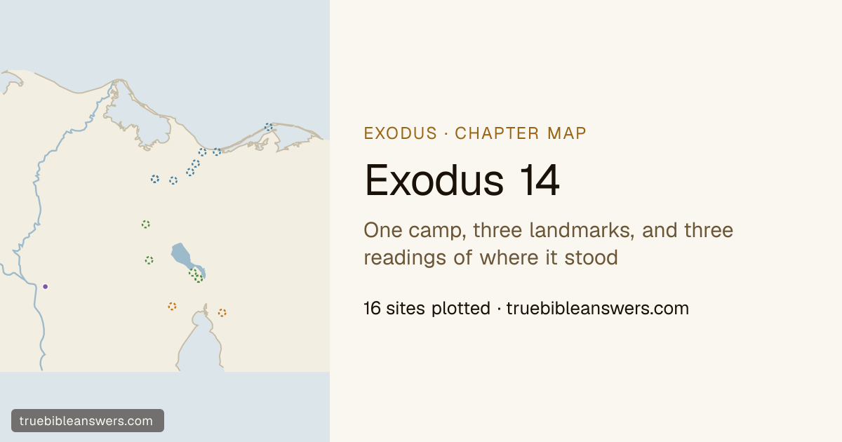
Read it →Exodus 14:2 fixes the camp more precisely than any other verse in the march: in front of Pi-hahiroth, between Migdol and the sea, in front of Baal-zephon. One place, three landmarks, a sightline to each. It is also the verse that has kept the route of the exodus open for the best part of two centuries, because those three names are the three nobody can find. Take each name's leading identification on its own and they land up to 82 km apart — Pi-hahiroth on a plain by the Bitter Lakes, Migdol and Baal-zephon away up on the old Pelusiac frontier — which is not a camp any scholar has proposed but an accident of counting each name's votes separately. So this map does not count them separately. Every site the sources put forward is drawn, in the colour of the reconstruction it belongs to: a northern reading that sets the camp on Egypt's fortified frontier and the crossing in the lagoons behind the Mediterranean bar, a lakes reading that keeps it on the isthmus among the reed marshes of Timsah and the Bitter Lakes, and a southern reading that takes it down to the head of the Gulf of Suez under Jebel Attaqa. None of the three names carries a pin, because none of the three readings has won. What the chapter itself says is not in doubt at all: the chariots come out of Egypt behind them, the sea goes back before an east wind that blows all night, Israel walks through on dry ground, and the water returns over the horsemen. Only the where is open, and the map says so three times over.
Regions on this map
Verses 1-20: one campsite, given three landmarks and a sightline to each, and between them the three names carry thirteen candidate sites spread over 154 km of the isthmus. Nothing here is pinned. Every proposal is drawn as an open ring in the colour of the reconstruction that offers it.
A shrine of the Canaanite storm god, and a sightline rather than a stop: Israel is told to camp "in front of" it, which means it could be seen from the shore, and a god of the north wind is a plausible thing for sailors to have put on a coast.
Not plotted. Tell Defenneh takes 217 of the 321 votes that name a site and would carry a pin if it stood alone. It does not stand alone: the camp it fixes is fixed by two other names whose votes go elsewhere.
"Between Migdol and the sea." Migdol is Egyptian for a watchtower and there was more than one of them on the eastern frontier, which is why the name attaches to a line of mounds down the isthmus rather than to any single one.
Not plotted. Tell el-Herr leads with 120 of 210 votes, but Exodus 14:2 stands Migdol beside Pi-hahiroth, whose own vote leads 82 km to the south.
The name the camp is given first, and the one the sources are least able to place: sixty of its hundred and eighty-one votes decline to name a site at all and say only that it lies within a kilometre of Baal-zephon, wherever Baal-zephon is.
Not plotted. Its leading site holds 64 of the 121 votes that name a site, and the sites behind it belong to a reconstruction 76 km away; a pin would settle a question the sources have not.
Verses 5-9 and 23-31: Egypt is named in ten verses of this chapter and never as somewhere anyone is going. It is what the column has left and what the chariots come out of. The dot is the gazetteer's nominal point for the whole country, at Ain Shams in modern Cairo; the pursuit is drawn from it and stops in open delta, because where it caught them depends on where the camp was.
Named in ten verses of this chapter and never as anywhere anyone is going: it is what the column has left, what the chariots come out of, and what the survivors on the shore are looking back at.
Today: Egypt (nominal point at Ain Shams, Cairo) (representative point)
Verses 21-29: eight of those nine name no place, which is why this map keeps them. Three tracks cross, one for each reading, each over the water that reading crosses. The three short tracks that go in and stop are the Egyptians.
Exodus 14, verse by verse
- Exodus 14:2“Tell the people of Israel to turn back and encamp in front of , between and the sea, in front of ; you shall encamp facing it, by the sea.
- Exodus 14:5When the king of was told that the people had fled, the mind of Pharaoh and his servants was changed toward the people, and they said, “What is this we have done, that we have let Israel go from serving us?”
- Exodus 14:7and took six hundred chosen chariots and all the other chariots of with officers over all of them.
- Exodus 14:8And the LORD hardened the heart of Pharaoh king of , and he pursued the people of Israel while the people of Israel were going out defiantly.
- Exodus 14:9The Egyptians pursued them, all Pharaoh's horses and chariots and his horsemen and his army, and overtook them encamped at the sea, by , in front of .
- Exodus 14:11They said to Moses, “Is it because there are no graves in that you have taken us away to die in the wilderness? What have you done to us in bringing us out of ?
- Exodus 14:12Is not this what we said to you in : ‘Leave us alone that we may serve the ’? For it would have been better for us to serve the than to die in the wilderness.”
- Exodus 14:18And the shall know that I am the LORD, when I have gotten glory over Pharaoh, his chariots, and his horsemen.”
- Exodus 14:20coming between the host of and the host of Israel. And there was the cloud and the darkness. And it lit up the night without one coming near the other all night.
- Exodus 14:25clogging their chariot wheels so that they drove heavily. And the said, “Let us flee from before Israel, for the LORD fights for them against the .”
- Exodus 14:30Thus the LORD saved Israel that day from the hand of the , and Israel saw the dead on the seashore.
- Exodus 14:31Israel saw the great power that the LORD used against the , so the people feared the LORD, and they believed in the LORD and in his servant Moses.
Where the sources put the contested places
3 names on this map carry no pin, because the sources have not settled where they are. Every site proposed is drawn instead, in the colour of the reconstruction it belongs to.
- The northern reading
- The camp on Egypt's fortified north-eastern frontier and the crossing in the lagoons behind the Mediterranean bar. It has the Egyptian evidence on its side: migdol is Egyptian for a fort, the frontier road out of Egypt ran past several of them, and Baal-zephon is greeted by name in a letter from Tahpanhes. It is a family rather than a single proposal — its sites spread 94 km, and the water is the Ballah lakes for some, Lake Manzala for others, and the Sirbonis lagoon behind Mount Casius for the rest.
- The lakes reading
- The camp on the isthmus between Lake Timsah and the Bitter Lakes, and the crossing in the reed marshes there. It keeps the march on the Wadi Tumilat road out of Succoth, which is the one earlier stage nobody argues about, and it reads yam suph literally: the papyrus that gives the sea its name grows in fresh water, which the Gulf of Suez has none of.
- The southern reading
- The camp at the head of the Gulf of Suez under Jebel Attaqa, and the crossing in salt water — a true arm of the Red Sea, which is what the Greek translators took yam suph to mean and what the traditional route on to Jebel Musa needs. It is the oldest of the three readings and the thinnest in the modern vote.
Baal-zephon
A shrine of the Canaanite storm god, and a sightline rather than a stop: Israel is told to camp "in front of" it, which means it could be seen from the shore, and a god of the north wind is a plausible thing for sailors to have put on a coast.
Not plotted. Tell Defenneh takes 217 of the 321 votes that name a site and would carry a pin if it stood alone. It does not stand alone: the camp it fixes is fixed by two other names whose votes go elsewhere.
The northern reading291 of 321 votes
- Tell Defenneh (Daphnae) · 217 votes — Two thirds of the vote, and the only candidate on this map with a text behind it: a sixth-century Phoenician letter found in Egypt sends greetings to "Baal-zephon and all the gods of Tahpanhes", and Tahpanhes is Tell Defenneh.
- Ras Kasrun (Mount Casius) · 40 votes — The sand ridge on the Bardawil bar that classical writers called Mount Casius and knew as a shrine of Zeus Kasios, a Greek storm god standing where a Canaanite one had. It is the northern reading's coastal variant: the camp on the bar, the sea the lagoon behind it.
- Al-Mahamdiyah · 34 votes — A point on the shore east of Pelusium, offered as the seaward end of that same coastal line without committing to Casius itself.
The lakes reading0 of 321 votes
No site is proposed for this name under this reading.
The southern reading30 of 321 votes
- Jebel al-Murr · 20 votes — A hill on the eastern side of the head of the Gulf of Suez, in sight of the water the southern reading crosses.
- Jebel Attaqa · 10 votes — The mountain standing over Suez that the traditional route runs beneath. On this reading the camp is shut in between it and the sea, which is what Pharaoh is made to say in verse 3.
Migdol
"Between Migdol and the sea." Migdol is Egyptian for a watchtower and there was more than one of them on the eastern frontier, which is why the name attaches to a line of mounds down the isthmus rather than to any single one.
Not plotted. Tell el-Herr leads with 120 of 210 votes, but Exodus 14:2 stands Migdol beside Pi-hahiroth, whose own vote leads 82 km to the south.
The northern reading140 of 210 votes
- Tell el-Herr · 120 votes — A fort on the road out of Egypt and the best-excavated candidate of the four; it is where the Migdol of Jeremiah and Ezekiel is usually placed, and it anchors the northern reading.
- T-211, by Tell el-Herr · 20 votes — A survey number rather than a name: a fort found a few kilometres from Tell el-Herr, and the northern reading's answer to the objection that Tell el-Herr's own walls are centuries too late.
The lakes reading70 of 210 votes
- Jebel Abu Hasa · 40 votes — A ridge at the southern end of the Bitter Lakes. A migdol is a watchtower before it is a fort, so the lakes reading looks for high ground over the water rather than for a garrison on a road.
- near Tell el-Maskhuta · 30 votes — Within ten kilometres of the mound at the eastern end of the Wadi Tumilat, which is also where most sources put Succoth — a Migdol on the road the march had just come down.
The southern reading0 of 210 votes
No site is proposed for this name under this reading.
Pi-hahiroth
The name the camp is given first, and the one the sources are least able to place: sixty of its hundred and eighty-one votes decline to name a site at all and say only that it lies within a kilometre of Baal-zephon, wherever Baal-zephon is.
Not plotted. Its leading site holds 64 of the 121 votes that name a site, and the sites behind it belong to a reconstruction 76 km away; a pin would settle a question the sources have not.
The northern reading37 of 121 votes
- Tell Defenneh (Daphnae) · 17 votes — Read as "the mouth of the canals", which suits a town on the Pelusiac branch; it is also where Baal-zephon's own vote goes, which is why the northern reading comes closest to holding all three landmarks together — about 30 km across, and no other reading gets them nearer.
- Tell el-Farama (Pelusium) · 10 votes — The frontier port at the eastern mouth of the Nile — the furthest north anyone puts the camp, and the reading that makes the sea the Mediterranean shallows.
- El Qantara · 10 votes — The crossing place of the Ballah lakes, where the road to Canaan left Egypt. A camp here stands on the frontier itself rather than behind it.
The lakes reading84 of 121 votes
- the plain by Jebel Jinaifa · 64 votes — The largest single block of votes for any Pi-hahiroth, and the only candidate that is open ground rather than a mound: a plain on the eastern shore of the Bitter Lakes wide enough to hold a nation with its back to the water.
- Jebel Abu Hasa · 10 votes — A ridge at the southern end of the Bitter Lakes, offered as the high ground the camp was pinned against — the same site the lakes reading offers for Migdol, which would put two of the three landmarks on one hill.
- the marsh west of the Bitter Lakes · 10 votes — Not a settlement but the wetland itself, on the argument that Pi-hahiroth names a feature of the water rather than a town beside it.
The southern reading0 of 121 votes
No site is proposed for this name under this reading.